 ar
ar bg
bg hr
hr cs
cs da
da nl
nl fi
fi fr
fr de
de el
el hi
hi it
it ko
ko no
no pl
pl pt
pt ro
ro ru
ru es
es sv
sv tl
tl iw
iw id
id lv
lv lt
lt sr
sr sk
sk sl
sl uk
uk vi
vi et
et hu
hu th
th tr
tr fa
fa ms
ms hy
hy ka
ka ur
ur bn
bn mn
mn ta
ta kk
kk uz
uz ku
ku
water gauge level
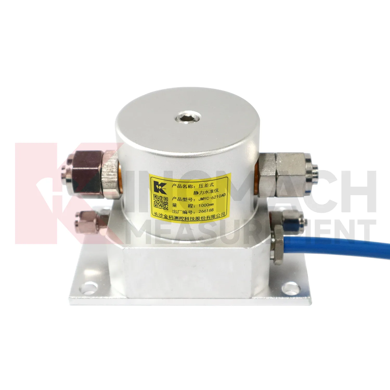
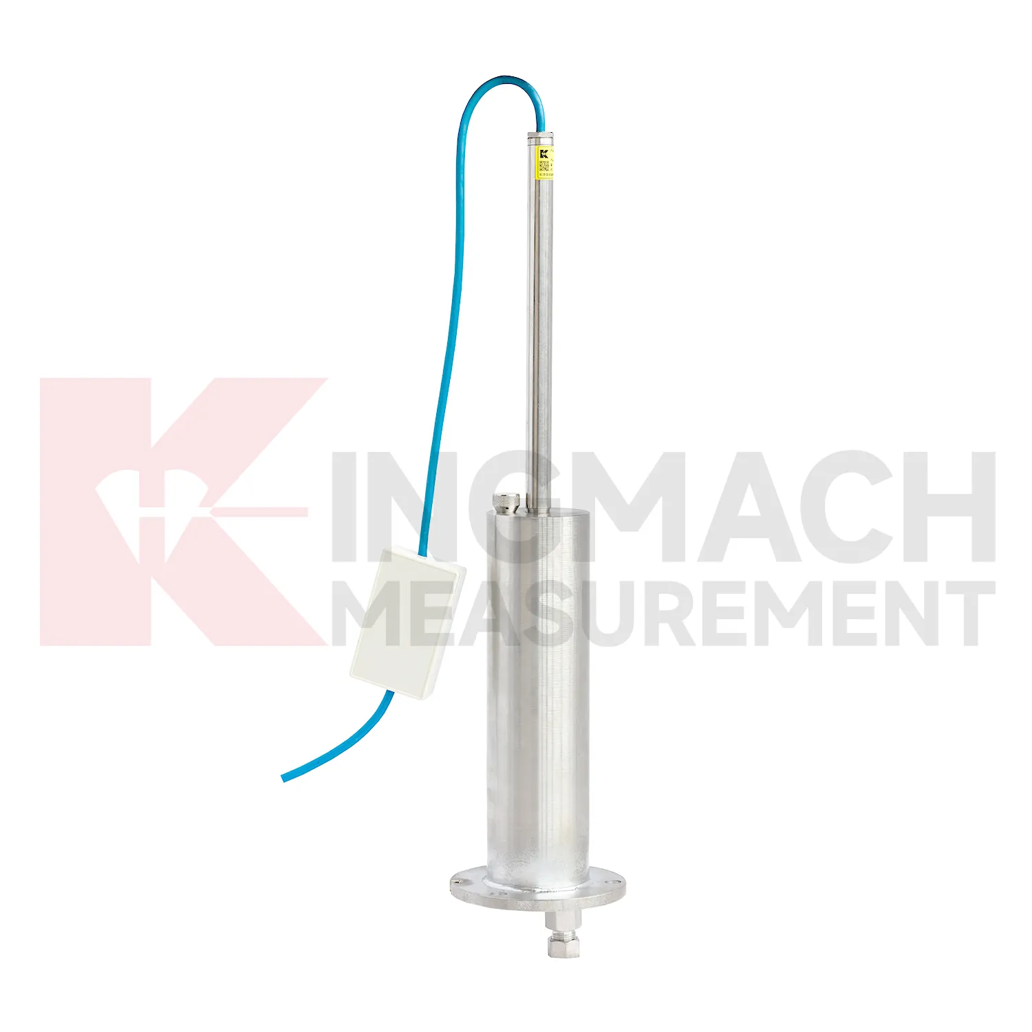
Data acquisition for Kingmach water gauge level can be arranged as manual checking, remote digital collection, or a mixed program. JMDL-47XXAT can be read by comprehensive testers or connected to automatic acquisition for remote transmission. JMDL-62XXADT, JMQJ-62XXADT, and JMYC-62XXAD provide RS485 output, which helps when several hydrostatic channels need to be read from a cabinet or platform. JMCJ-1003/1005 remains a field-reading instrument for magnetic ring depth and groundwater level confirmation. The acquisition plan should define sampling interval, channel address, unit display, reference point, abnormal-data review, and power backup. Manual readings are still useful after storms, construction impacts, cabinet faults, or unexpected curve jumps because they can confirm whether the instrument, reference, or site condition has changed. Good data handling also needs versioned baseline records, clear point names, and visible maintenance notes. Without that discipline, a long settlement curve may look complete but still be hard to trust during engineering review.
Application of water gauge level
In foundation pit projects, water gauge level are used during staged excavation to track base uplift, nearby pavement settlement, groundwater response, and vertical movement around retaining systems. The timing of each value matters because deformation may change after dewatering, support installation, soil removal, rainfall, or backfilling. Kingmach JMDL-47XXAT can be embedded to follow base uplift or local settlement, while JMCJ-1003/1005 can read magnetic ring depth and groundwater level in boreholes. Hydrostatic instruments may be added where several elevations around the pit need comparison against a reference. The site team should record excavation depth, support level, water pumping condition, adjacent road or building observations, and first stable baseline beside the settlement curve. If movement grows quickly, the response should include checking the sensor and reference first, then comparing support force, wall displacement, groundwater, and visual inspection before deciding whether excavation can continue. This keeps settlement review tied to the actual construction sequence, which is essential because a pit may behave differently at each excavation depth and support stage. A clear record also helps distinguish base rebound from surrounding ground loss or reference disturbance. The review file should also include reference condition, recent site work, nearby sensor behavior, and inspection notes so later teams can interpret the curve clearly.
The future of water gauge level
Data fusion will define the future role of water gauge level in structural health monitoring. Settlement should be reviewed beside displacement, tilt, strain, load, pore pressure, rainfall, vibration, and water level data. For example, a subgrade settlement trend may be more meaningful when rainfall and traffic loading are visible. A foundation pit uplift reading may need groundwater and support force context. A bridge deflection reading may need temperature and bearing information. Kingmach settlement products can provide the vertical movement layer in this wider record. When different sensor types are reviewed together, warnings can be based on relationships rather than a single number. That helps engineers prioritize site checks and avoid overreacting to harmless movement or missing linked changes across several instruments. Future platforms should make these relationships easy to review without hiding the raw settlement readings.
Care & Maintenance of water gauge level
Remote acquisition for water gauge level needs commissioning checks across the whole data chain. Verify RS485 wiring, bus address, power supply, channel name, units, reference point, and platform display before routine collection begins. For Kingmach hydrostatic sensors and automated settlement systems, move through each channel and confirm that the displayed point matches the physical location. Label cabinets, cables, tubes, and sensor numbers clearly. During operation, data gaps should be compared with power outages, communication faults, storms, cabinet work, or platform changes. If a sensor is replaced, record the old serial number, new serial number, old baseline, new baseline, and reason for replacement. Remote data is only trustworthy when the physical point and digital channel stay aligned. The record should include who inspected the point, what changed on site, and whether nearby instruments showed the same trend, so the maintenance team can separate sensor trouble from real settlement. The record should include who inspected the point, what changed on site, and whether nearby instruments showed the same trend, so the maintenance team can separate sensor trouble from real settlement.
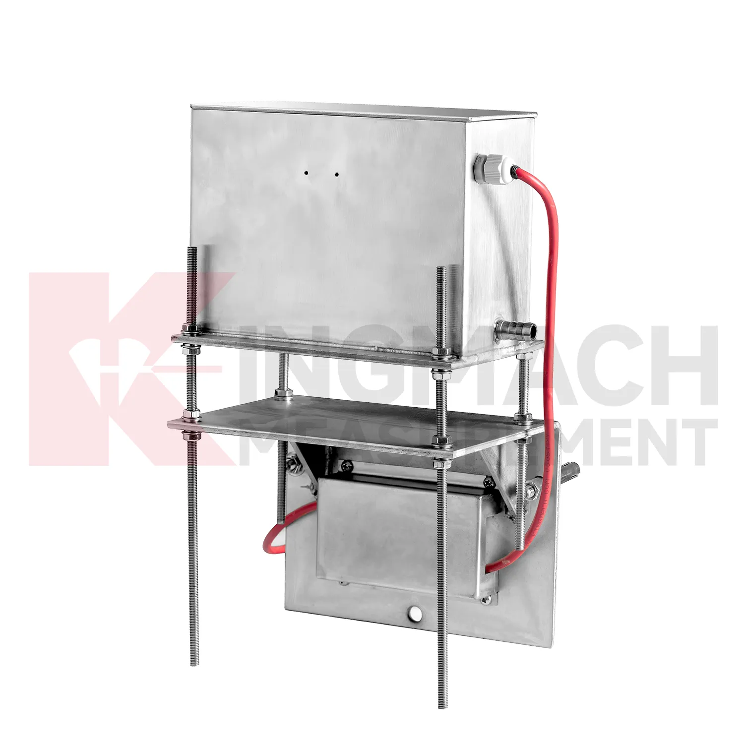
Kingmach water gauge level
water gauge level are used when vertical movement must be measured before it becomes visible as cracks, uneven pavement, rail irregularity, or structural distress. Kingmach settlement products cover embedded single-point measurement, hydrostatic leveling, wide-range differential pressure monitoring, magnetic ring settlement and water level reading, and micro range deflection monitoring. On a roadbed, the reading may show whether filling and compaction are stabilizing. On a bridge, it may show deflection relative to a reference point. In a foundation pit, it may show base uplift after excavation or dewatering. The key is to treat settlement as a time-based record, not a one-time survey value. Each point should carry its model, range, reference point, baseline, installation depth, and acquisition channel so later engineers can understand what moved, when it moved, and why the value matters. During review, the team should compare the value with nearby points, construction timing, water condition, and inspection notes before deciding whether the movement is acceptable.
FAQ
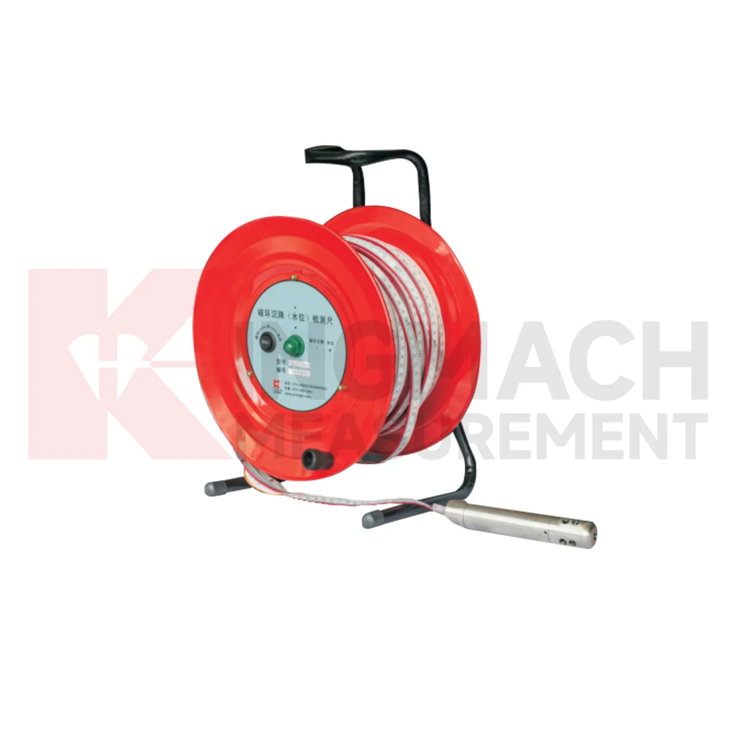
Q: What is JMCJ-1003/1005 used for?
A: It is used to measure layered underground settlement and groundwater level in foundations, subgrades, foundation pits, embankments, and underground structures.
Q: How does magnetic ring settlement reading work?
A: Magnetic rings are placed underground; when the probe senses a ring, audible and visual alerts help the operator read depth from the steel tape at the borehole.
Q: How is water level detected?
A: The water level component works by water conductivity and alerts when the probe contacts water.
Q: What accuracy is listed?
A: The listed measurement accuracy is plus or minus 1 mm.
Q: What field records are needed?
A: Keep borehole number, magnetic ring depth, previous reading, current reading, groundwater level, and operator notes together.
Reviews
Robert Taylor
The weir flow meter is well-built and delivers accurate measurements. Great value for water management applications.
Matthew Garcia
Instrumentation cables are durable and perform well even in harsh environments. Will definitely order again.
Latest Inquiries
To protect the privacy of our buyers, only public service email domains like Gmail, Yahoo, and MSN will be displayed. Additionally, only a limited portion of the inquiry content will be shown.
Emma***@gmail.comCanada
Dear Sir/Madam, we are interested in displacement transducers and settlement sensors for a geotechni...
Mia***@gmail.comNetherlands
Dear team, we are interested in your readouts & data loggers compatible with multiple sensors. Do yo...
Related product categories
- water level gauge
- water gauge water level gauge
- water gauge level
- gauge water level
- Magnetic Ring Settlement Water Level Gauge
- Optical Deflection Monitor
- Tilt Sensor
- Deflectometer
- Micro Range Hydrostatic Level Sensor
- Single-point Settlement Meter
- Optical Deflection Monitor
- Inclinometer-based Hydrostatic Leveling System